In June/July this year, I will be returning to the US to hike the Tahoe Rim Trail. As well as this hike, I will also be completing the final stage of the John Muir Trail from Kearsarge through to Whitney which was caught short by snow in 2015.
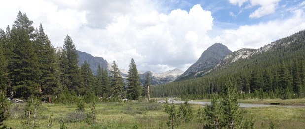
The TRT has some incredible scenery which is very similar in some respects to parts of the JMT which I hiked in 2015. The combination of the beautiful trees and granite rocks and the lake itself should make for a stunning combination. It is also a logistically easy trail being a loop which makes it simpler in many respects.

The Tahoe Rim Trail is described by Wikipedia as follows:
The Tahoe Rim Trail is a 165-mile (266 km) long-distance hiking trail that forms a loop around the Lake Tahoe Basin in the Sierra Nevada and Carson ranges of California and Nevada in the United States. The trail ranges in elevation from 6,240 feet (1,900 m) at the outlet of Lake Tahoe to 10,338 feet (3,151 m) at Relay Peak in Nevada. About 50 miles (80 km) of trail above the lake’s west shore are also part of the much longer Pacific Crest Trail. Additionally, 96 Miles of the trail along the east and south sides of the Lake Tahoe basin are designated as a National Recreation Trail.
The idea of a crest trail around Lake Tahoe was first proposed in 1978 by Glenn Hampton, a recreation officer of the Lake Tahoe Basin Management Unit (LTBMU) of the U.S. Forest Service. The trail was completed in September 2001, almost entirely through volunteer effort. The trail currently exists mostly on land managed by the LTBMU and Lake Tahoe-Nevada State Park, with shorter segments in the Tahoe National Forest and the Carson Ranger District of the Humboldt-Toiyabe National Forest.
The main hiking season is usually from July through September, though lingering snow patches may sometimes be found into August of high snow years. The trail is open year-round, but is not marked for winter use. The climate is typical of the Sierra Nevada, with severe storms during the winter and almost no precipitation falling in the summer.
The plan is to fly into San Fransisco in mid-June and spend a few days in Concord getting organised and sending mail drops. From there, we will head to Lake Tahoe and to one of the trailheads there to commence our hike. We plan to complete the trail in around 12 days with a nero in Tahoe City.
From there, we will head south to Lone Pine and Independence and start the JMT again entering through Kearsarge Pass. We plan on lower mileages on the JMT due to the higher altitude and difficulties of the remaining sections we have to complete being Forrester Pass and Whitney.

For the previous entries relating to my previous JMT hike which finished at Kearsarge, you can go to here. The snow levels in 2015 were virtually non-existent even though we had some bad weather at the end.
This time, we will be well and truly prepared with microspikes and cooler weather gear, as well as the benefits of our previous experience hiking in the Sierras. The snow levels in 2018 are likely to be significantly higher than in 2015 yet still below average.
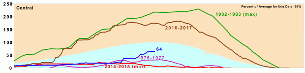
California snow water content at 30 March 2018
We’re looking forward to a great hike in the US and I will be blogging daily from the trail.
I will also post updates over the next 10 weeks as we get closer and closer to our start date – including a 5 day training hike next week on the Bibbulmun Track here in Western Australia. Stay tuned!

Enjoy your visit. I plan to hike Mt. Whitney, and the JMT in Yosemite in September. It will be my first visit. Cheers.
LikeLike
Thank you, Pete. You will love both, have a great trip!
LikeLiked by 1 person