Day 5: Cruising into Donnelly River

Tom Road campsite to Donnelly River

Mileage: 10.1 miles/16.2 km

Sectional total: 66.7 miles/106.8 km

I had a really good night’s sleep last night. The bush was pretty quiet as were the school group and the only thing to disturb my sleep was the waning moon rising later in the night and shining straight into the tent.

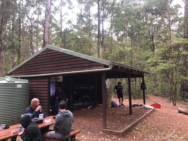
We had a good chat with the teachers and kids in the morning at the campsite. A lot of the kids had never stayed overnight in the wilds before and it was a big experience for them. It was great to speak to the teachers and it was clear the kids just needed some positive words of encouragement speaking into their lives. One of them asked us if we were professional hikers to which I responded ‘We wish!….’.

IMG_0449

Continue reading

Day 4: Back on the flats

Boarding House to Tom Road campsite

Mileage: 13.9 miles/22.3 km

Sectional total: 56.6 miles/90.6 km

I ended up putting my tent up last night around 10pm as there was a fair bit of snoring going on in the shelter. I had a good night sleep in the end. The tent sites on the trail can be a bit hit and miss but the ones on this section are great as they have woodchips. This makes for a comfortable nights sleep rather than the hard rock common in the north.

We got going around 7.30 AM and it was clear that this was going to be a much easier day than the last two days. In many ways this was a bit of a transitional day with karri in the morning and jarrah in the afternoon.

Continue reading

Day 3: Up and down and back up again

Beavis campsite to Boarding House campsite

Mileage: 12 miles/19.2 km

Sectional total: 42.7 miles/68.3 km

Today’s section is notorious on the Bibbulmun as being one of the hardest sections on the entire trail. This is because of three very steep climbs and descents of which one, known as the ‘V’, is very unforgiving. This is particularly the case for southbounders as the climb for them has no switchbacks and goes straight up.

The trail started off in a benign way from Beavis and was pretty straightforward for the first couple of km. After that, it was the first big climb of the day. It certainly got the heart pumping and the calf muscles. Whilst tough, it is all great training. I can’t imagine how people with 30kg packs manage this section though as it’s pretty tough.

Continue reading

Pemberton to Donnelly River – April 2018

As part of my training hikes for my upcoming Tahoe Rim Trail/John Muir Trail hikes in the US, I will be doing a week on the Bibbulmun Track starting from tomorrow between Pemberton and Donnelly River.

Pemberton is a town in the South West of Western Australia and was named after the original settler Pemberton Walcott being founded in 1862. We will be walking north along the track towards Donnelly River, an old timber mill town.

2013-06-07 at 12-01-27

Continue reading

Thoughts on the Bibbulmun Track

Having now completed my thru-hike of the Bibbulmun Track, I thought it was worth providing some thoughts on the trail as a whole. Hopefully, this will prove to be of some value to future thru-hikers (or end-to-enders as they are referred to in Australia) considering hiking the trail and also in planning their future hikes.

Trail overview

bibbulmun

The route of the Bibbulmun Track

The route of the trail takes in the best of what Perth, the southwest and southern regions of Western Australia have to offer. From the extensive jarrah forests of the north, through the granite outcrops and viewpoints of the monadnocks, through the transition area to karri forest and onto the plains and wetlands and finally the southern coastal region. The trail allows the hiker to experience the best of these areas and to immerse oneself in the experience.

The trail is long enough in that it can grant a sufficiently extended hike to allow an individual to really get a proper thru-hike experience.

It is also short enough in that it is manageable for people to fit into their lives, particularly those who are in full-time employment and would find it difficult to take off longer periods of time. This hike can be accomplished without needing to resign from your job or take a career break (unless you would like to of course).

Continue reading

Day 43: The finish

Mutton Bird Campsite (977.7 km) to Albany (1,002.3 km)

Mileage: 24.6 km/15.4 miles

We started bright and early from Mutton Bird campsite at 6 AM having risen around 4.30 AM. It’s amazing how quickly the body clock adjusts to the daylight hours and your routine adjusts to that schedule. At the moment in Western Australia at this latitude, it gets light at that time and is not fully dark until 8.30 PM so there is plenty of available hiking time.

The morning started with a few isolated rain showers which were a feature of the first few days. Fortunately, these had mostly cleared by the time we got underway.

Morning rainfall at sunrise

Continue reading

Day 41: Across the Nullaki

Denmark (917.6 km) to West Cape Howe Campsite (948.8 km)

Mileage: 31.2 km/19.5 miles (+1.8 km side trail from town)

It was good to rest and refresh in Denmark yesterday. The town has several cafes (yes, chai latte…) and a large supermarket so I was able to get the resupply done for the final three day stretch into the end of the trail in Albany.

To leave Denmark, you need to get across to the Nullaki peninsula which can be done by foot (the long way), road (the cheap way) or boat (the 007 way). Being the debonair individual that I am, I chose the boat and arranged for John from Madfish Charters to take us across Wilson Inlet. Our little cheery boat arrived at 7 AM exactly to take us across the 3km inlet. The good news is those kms are included in the official trail km so we don’t have to walk them.

Continue reading